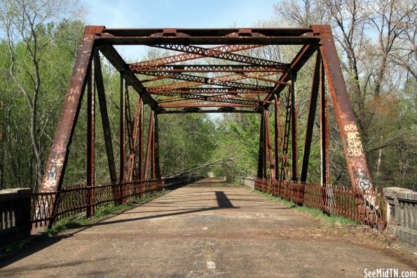
The Obion Bridge crosses the Obion River near the town of Obion, TN. in Obion County. It's importance in town is demonstrated by it appearance in the town's logo and "welcome to" sign. But, today it's closed to traffic, and probably always will be. Located in Northwest Tennessee, this was part of the first main road to connect Memphis to St. Louis. when highways had names instead of numbers, it was part of the Jefferson Davis Highway. Locally, it became highway TN3, but federally it was US51 which connected New Orleans to Wisconsin. The bridge was first designed in 1927 when federal funds helped Tennessee create a series of 14 toll bridges. Each of these 14 bridges were named after a war hero. This bridge was named in honor of World War I Medal of Honor recipient Joseph B. Adkinson. The bridge officially opened in 1931. Tolls were eventually removed from this and the other bridges in 1947. The Obion River itself isn't that wide of a river, however the area around it is prone to frequent flooding, thus it is has a wide flood plane with levees on either side. The entire bridge is almost 3,000 feet long, but the single steel truss in the middle is only 102 feet. The lengthy concrete approaches include 45 girders which are supported by 4 concrete piers, 97 concrete bent piers and two concrete abutments. The city of Obion started as a railroad town. Illinois Central had tracks going through town, and the only vintage steam train water tank remaining in Tennessee is in town. Today the tracks are also used by the Amtrak "City of New Orleans" line with a bridge a few feet to the east of this one. The nearest city to the south is Trimble, in Dyer County, about three miles away. As the decades passed, this bridge and highway could not support the increased traffic. TDOT had a goal to replace the two lane highway of the entire length of US51 throughout Tennessee with a new highway built to freeway standards. Eventually, the new US51 will become Interstate 69m and part of the NAFTA Superhighway. That segment which parallels this old stretch of highway was completed in 1990. Most of old US51 is still drivable. However, the segment with this bridge is abandoned. I wish they could reopen it, but as I walked through here, I can tell it would cost too much to repair. In some spots, the concrete roadway is missing. Trees are growing through steel beams. several of the guardrails look loose. It's probably unsafe for a bicycle. But it is walkable. You can drive a little ways up to the bridge, but there are large barricades which prevent getting too close. Sadly, there's a lot of trash and graffiti left behind.
